
Between the years 37 and 36 BCE, Marco Vipsanius Agrippa, personal friend and right-hand man of Emperor Augustus, established the foundation of the most important Roman fleet (the classis Misenensis) at Portus Iulius, built for this purpose between Baiae and Puteoli (modern-day Pozzuoli in the Gulf of Naples) by the engineer Lucius Cocceius Auctus.
Authors such as Virgil or Pliny the Elder documented the challenges and achievements of building the port, considering it one of the principal wonders of Roman engineering.
Agrippa’s plan involved constructing a large port complex that extended across several facilities inland.

Initially, the primitive and small port on the coast was connected to the nearby Lake Lucrinus by a short canal with a hidden entrance, providing access to the Tyrrhenian Sea. Then, another longer canal, about 350 meters in length, linked Lake Lucrinus to Lake Avernus further inland.
Agrippa knew that Lake Avernus, invisible from the sea and even from the bay itself, would provide a secure harbor where the fleet could remain hidden and secret until ready to operate.
In Cumae, in Campania, there is a region shaped like a crescent between Misenum and Puteoli, surrounded by small, bare mountains, except at some points, enclosing a gulf divided into three lagoons. One of them, the outer one, extends before the cities; the middle one is separated from the outer one by a narrow strip of land, and the one seen in the background is marshy. The latter is called Avernus; the middle one, Lake Lucrinus, and the outer one, which is part of the Tyrrhenian Sea, belongs to it and receives its name from it. In that inland sea which was between the other two parts, Agrippa, then opening two narrow canals in the strip of land that separated Lake Lucrinus from the open sea, each near the mainland, created two excellent ports for anchoring ships.
Dio Cassius, Roman History XLVIII.50

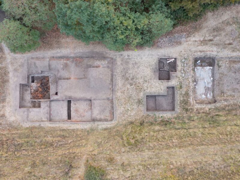
Docks and shipyards were built for ship repair and construction, and a coastal dock about 372 meters long was constructed on arches supported by 15 square pylons.
A long wall from Punta dell’Epitaffio to Punta Caruso, already on the shore of Lake Lucrinus and traversed by the Herculanea road, protected the installations. It was on this wall where the secret entrance allowing ships to enter the lake was located.
Some authors believe that the existing port behind Cape Misenum, where the fleet base was finally moved to in 12 BCE, served as a mooring for active ships, while the inner port of Lake Avernus was used only for repairs and as a refuge during storms.

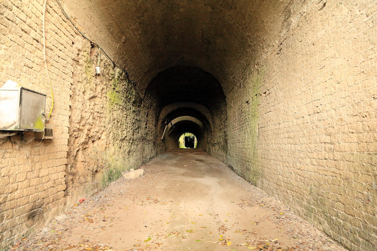
Finally, Lake Avernus was connected to the walled city of Cumae by a long road tunnel, which could serve as an escape route if necessary.
This tunnel still exists and is known as Grotta di Cocceio (after the engineer Lucius Cocceius Auctus, who designed and built it).
It is almost a kilometer in length, with a gradient of 40 meters, a height of up to 12 meters, and a width of between 5 and 6 meters, enough to allow the passage of two carts side by side, excavated in the volcanic tuff of Mount Grillo under which the road runs. Therefore, it is considered the first major Roman road tunnel, and possibly in the world.

The entrance from Lake Avernus side was preceded by a vestibule adorned with a colonnade in which niches with sculptures were arranged, which no longer exist today. Nine vertical shafts were constructed on the hill to ventilate and illuminate the interior, the largest of which reaches over 30 meters in height. The tunnel ends in the center of the city of Cumae.
At the same time, another tunnel was excavated parallel to the road on the north side for the Aqua Augusta, the aqueduct that supplied water to the naval base and the cities in the area, also with niches and vertical shafts.
With the transfer of the naval base to Misenum in 12 BCE, the tunnel lost its strategic importance and military character, although it continued to be used as a civilian communication and trade route.

At some point in the late Antiquity and early Middle Ages, it fell out of use, probably in relation to one of the eruptions of Vesuvius, and was not rediscovered until the 19th century, during archaeological excavations promoted by the Bourbon kings of Naples.
During World War II, it suffered damage when some of the explosives stored inside accidentally detonated.
Restoration and consolidation works began in 2017, seemingly interrupted by the presence of five species of protected bats inside.
This article was first published on our Spanish Edition on April 5, 2024. Puedes leer la versión en español en Gruta de Cocceio, el primer gran túnel de carretera del mundo, construido por los romanos en 36 a.C.
Sources
Grotta di Cocceio (Parco Archeologico Campi Flegrei) | Grotta di Cocceio, la casa dei pipistrelli | Parco archeologico dei Campi Flegrei – Grotta di Cocceio (Ministero della Cultura) | Wikipedia
- Share this article:


Discover more from LBV Magazine English Edition
Subscribe to get the latest posts sent to your email.


Qian Xuesen, the Scientist Expelled from the United States Who Brought China Into the Space Race
On October 31, 2009, an elderly man, nearly a century old, passed away in Beijing. His name was Qian Xuesen, and in China, he is considered a national hero for…
Two Wines Dominated the Market in Late Antiquity in the Mediterranean: Gaza and Cilician
A recent study has brought to light interesting details about the distribution and consumption patterns of two of the most important wines in the eastern Mediterranean during Late Antiquity. These…
Farnese Atlas, the First Known Representation of the Celestial Sphere
Atlas was one of the Titans in Greek mythology, son of Iapetus and the Oceanid Clymene, and brother of Prometheus. After the war against the Olympian gods, Zeus condemned him…

Orsippus of Megara, the First Athlete to Compete Naked in the Olympic Games
A quick glance at any artwork from Ancient Greece gives an idea of the almost religious importance of nudity, and if we interpret the images literally, how widespread its practice…
Sandby Borg, the Place where Archaeologists Found a Chilling Iron Age Scene Frozen in Time
The isolated island of Öland, off the southeastern coast of Sweden, holds within its windswept landscape the eroded remains of several fornborgs, circular stone fortifications built during the Iron Age.…

An Enigmatic Roman Altar Found in England Was Dedicated by a Soldier Stationed on the Danube, in a Legion That Was Never in Britain
A Roman altar dedicated to Mars, found in Marton, Lincolnshire, has revealed a fascinating connection to a soldier of the XI Claudia Legion of the Roman Empire. The altar, which…
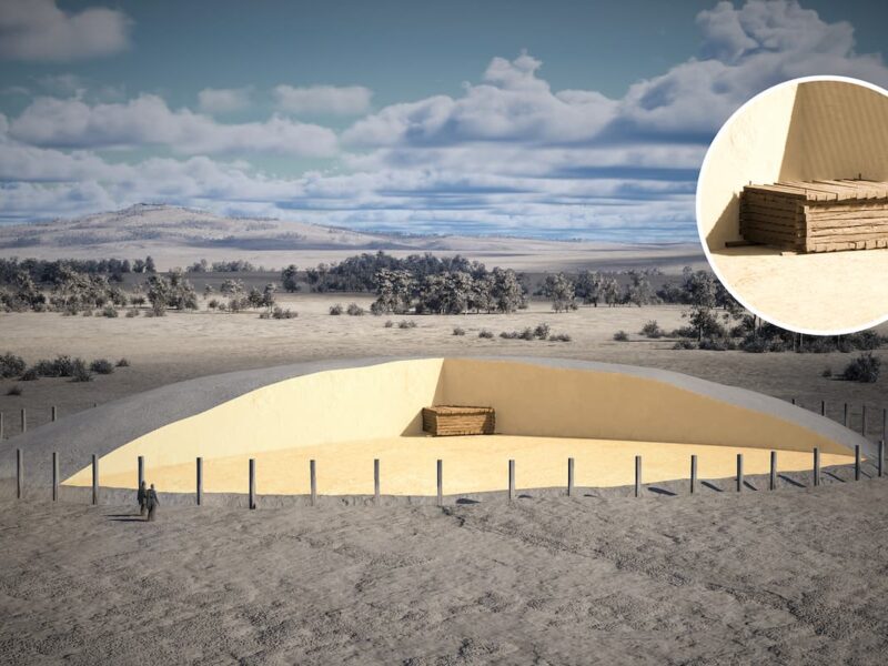
Spectacular Celtic Burial Chamber from the 6th Century BC Discovered in the Center of a 65-Meter-Diameter Burial Mound in Germany
In a remarkable archaeological discovery in the Danube Plain, near Riedlingen, Baden-Württemberg (Germany), an early Celtic burial chamber has come to light. This find is located at the center of…
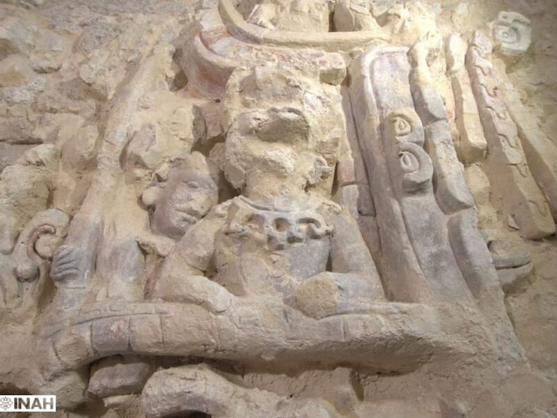
Reliefs with Figures of Guardians, Celestial Ancestors, and Mythical Animals of the Kaanu’l Mayan Dynasty Found in Mexico
The recent archaeological discovery in the Dzibanché Archaeological Zone, Quintana Roo (Mexico), has provided new insights into the grandeur of the Kaanu’l dynasty, one of the most influential in the…
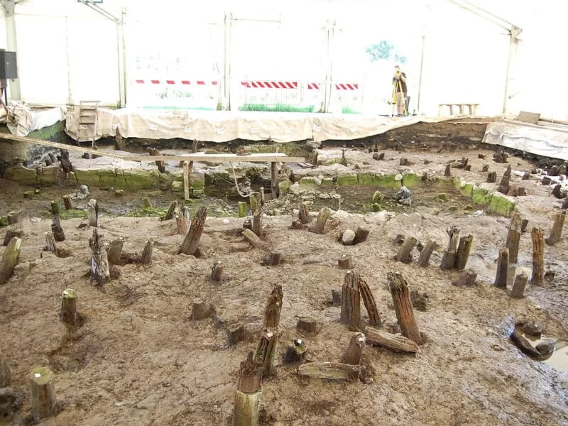
Lucone di Polpenazze, the Bronze Age pile-dwelling settlement that was preserved because a fire caused it to collapse into the lake
Located in the Lombardy region, near the impressive Lake Garda, the archaeological site of Lucone di Polpenazze is a living testament to Prehistory in northern Italy. This place, a large…
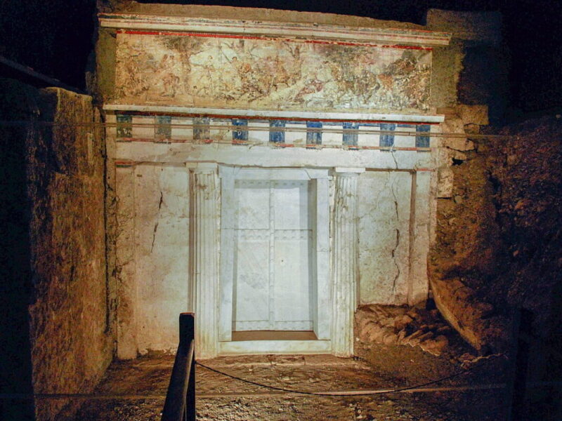
Sacred tunic of Alexander the Great identified in one of the Macedonian tombs at Vergina in Greece
A recent discovery in Tomb II at Vergina, Macedonia, Greece, has revealed what appears to be the sacred “chiton” or tunic of Alexander the Great, a finding that could change…
A House from 8,000 Years Ago Found in Serbia Belonged to the First Sedentary Farmers of Europe
Did the first agricultural societies in Europe live nomadically, or were they (seasonally) sedentary? How did sedentarism spread between Anatolia and Europe, and how did the first sedentary people influence…
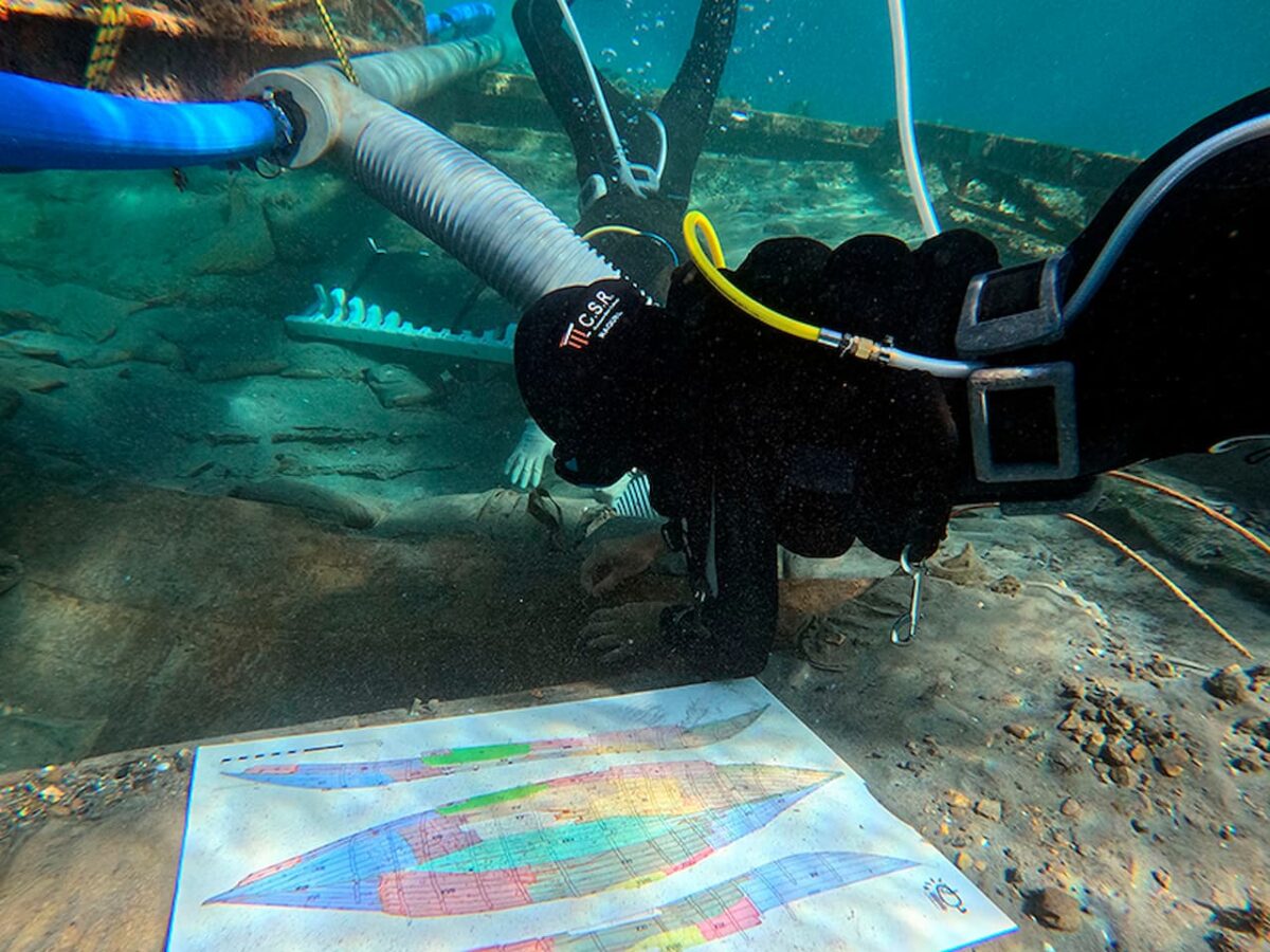
New findings during the extraction of a Phoenician shipwreck in Spain, the most complete ancient vessel found in the Mediterranean Sea
The much-anticipated start of the extraction of the Phoenician shipwreck located in Mazarrón, Murcia, named Mazarrón 2—currently the most complete ancient ship found in the Mediterranean—has begun with a series…
Something went wrong. Please refresh the page and/or try again.

_01.jpg)